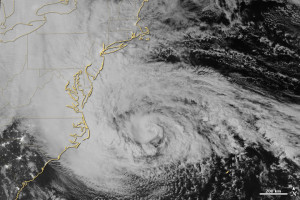
Few images are as beautiful and as terrifying as a satellite view of a hurricane about to make landfall. On October 29, 2012, the Suomi NPP satellite captured an ominous nighttime view of Sandy—an enormous hybrid storm that was part hurricane, part Nor‘easter—churning off the coast of New Jersey.
The string of city lights that stretches from Washington to Boston was mostly gone, blanketed by thick, ghostly storm clouds. One of the most brightly lit cities in the world, New York, was little more than a faint smudge through Sandy’s clouds.
In a matter of hours, that smudge of light would go dark. Large swaths of Manhattan were under water. The Rockaways were on fire. Rooftops along the New Jersey shore became temporary islands for people escaping a wall of seawater that surged inland.
Was Superstorm Sandy an expression of a “new normal” for our weather? Was it a storm pumped up by global warming?
“If you look at the unique set of circumstances in which Sandy emerged and you know something about meteorology and climate,” says Marshall Shepherd, director of the atmospheric sciences program at the University of Georgia, “it’s hard not to ask yourself these kinds of questions.”
Read the full story at
NASA Earth Observatory, March 2013

