pilanesbergmountains_pho_2015187

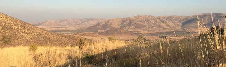
While big game animals such as lions, leopards, elephants, rhinos, and water buffaloes draw most visitors to Pilanesberg National Park, the land these animals live on is just as compelling. Pilanesberg is located in one of the world’s largest and best preserved alkaline ring dike complexes—a rare circular feature that emerged from the subterranean plumbing of an ancient volcano.

The Operational Land Imager (OLI) on Landsat 8 acquired this image of the park in South Africa on June 19, 2015. Seen from above, the concentric rings of hills and valleys make a near perfect circle, with different rings composed of different types of igneous rock. The entire structure sits about 100 to 500 meters (300 to 1,600 feet) above the surrounding landscape.

Read the full story at
NASA Earth Observatory, July 2015

mississippi_oli_2014

Ten thousand River Commissions, with the mines of the world at their back, can not tame that lawless stream, can not curb it or confine it, can not say to it, Go here or Go there, and make it obey. —Mark Twain, Life on the Mississippi

Twain’s pessimism has done little to deter the Mississippi River Commission. Since it was created in 1879, this division of the U.S. Army Corps of Engineers has waged a prolonged campaign to control the river. Their weapons in the battle are levees, dams, spillways, dikes, weirs and other pieces of infrastructure. Their mission is to prevent the river from abandoning its current course.

Left alone, nature would probably send the Lower Mississippi River whipping back and forth across a 200-mile arc every few thousand years. Like “a pianist playing with one hand,” is how John McPhee described the river’s restlessness in a story for The New Yorker. With the main channel flowing unusually far to the east in its current configuration, the Mississippi is primed to snap back toward the west. Such a change would send most of the Mississippi’s flow into the Atchafalaya River, a distributory (the opposite of a tributary) of the Mississippi and Red Rivers. Such a change would pose an existential crisis for port cities like New Orleans and Baton Rouge, starving them of the water that has come to define them.

Read the full story at
The NASA Earth Observatory, March 2015

sandy_vir_2012303

Few images are as beautiful and as terrifying as a satellite view of a hurricane about to make landfall. On October 29, 2012, the Suomi NPP satellite captured an ominous nighttime view of Sandy—an enormous hybrid storm that was part hurricane, part Nor‘easter—churning off the coast of New Jersey.

The string of city lights that stretches from Washington to Boston was mostly gone, blanketed by thick, ghostly storm clouds. One of the most brightly lit cities in the world, New York, was little more than a faint smudge through Sandy’s clouds.

In a matter of hours, that smudge of light would go dark. Large swaths of Manhattan were under water. The Rockaways were on fire. Rooftops along the New Jersey shore became temporary islands for people escaping a wall of seawater that surged inland.

Was Superstorm Sandy an expression of a “new normal” for our weather? Was it a storm pumped up by global warming?

“If you look at the unique set of circumstances in which Sandy emerged and you know something about meteorology and climate,” says Marshall Shepherd, director of the atmospheric sciences program at the University of Georgia, “it’s hard not to ask yourself these kinds of questions.”

Read the full story at
NASA Earth Observatory, March  2013

S09-41-2792_crop_720

When astronauts talk about viewing Earth from space, the conversation often turns to the planet’s mesmerizing beauty. They describe views of aquamarine coral reefs glimmering amidst the deep blue ocean; of armies of sand dunes marching across deserts; of clouds and lightning flashes dancing through the atmosphere.

For many, the view is deeply humbling. “For the first time in my life, I saw the horizon as a curved line. It was accentuated by a thin seam of dark blue light: the atmosphere,” said Ulf Merbold, a German astronaut who flew on Space Shuttle Columbia in 1983. “This was not the ‘ocean’ of air I had been told it was…I was terrified by its fragile appearance.”

For some astronauts, that thin blue line has appeared quite vulnerable. Many have noticed palls of haze lingering over parts of the world, the result of millions of tiny particles drifting in the atmosphere. Aerosol particles, which can be either liquid or solid, obstruct sunlight and cause distinct and vibrant features to blend into a hazy, featureless mélange of gray.

The particles that affect visibility have many sources, some of them natural. For instance, winds blow bits of dust and dried soil aloft; volcanoes occasionally belch thick plumes of ash; forest fires produce smoke; even vegetation and plankton can emit substances that contribute to haze.

Read the full story at:
NASA Earth Observatory, June 2014

ISS037-E-017916
Eight thousand is a perfectly arbitrary number. Yet, no other number looms larger for mountain climbers.

Fourteen mountain peaks stand taller than 8,000 meters (26,247 feet). There could have been many more of these “eight-thousanders” if the French commission that established the length of the meter (in 1793) had made it just a bit shorter; there would be hardly any if they had made the meter longer. The decision to make a meter equivalent to one ten-millionth of the distance between the equator and the North Pole left the world with fourteen 8K peaks. All of them are found in either the Karakoram or Himalayan mountain ranges of central Asia.

Fourteen is a number that pushes climbers to the point of obsession. It’s big enough that only the most ambitious consider climbing all of them, but small enough that doing so over a lifetime still seems possible. Even in the United States, a country where most people shun metric measurements, climbers dream of ascending the eight-thousanders. The “twenty-six-thousand, two-hundred-and-forty-seven-footers” hardly has the same ring.

racesplaces2013oct500x310

I’m in the parking lot of the visitor’s center at Harper’s Ferry National Historical Park in West Virginia, the first of four parks I’ll traverse today, waiting for the start of the Freedom’s Run Marathon. In the half-light of October dawn, the scene is surreal.

There’s a golden glow on everything, from the sculpted Blue Ridge Mountains above to the winding waters of the Shenandoah and Potomac rivers below. At the confluence of the two, water has sliced through two separate ridges, creating a distinctive notch in the mountains. Meanwhile, a few runners wearing garbage bags to keep warm wander past.

Read the full story at:
Runner’s World, September, 2013