An interesting new study published in Nature points out that an increase in the strength of the Arctic Oscillation between 2005 and 2008 caused winds in the region to grow more cyclonic and shift ocean currents in ways that drew more upper-surface freshwater from Russian rivers toward the Canada Basin and the Beaufort Sea. To see the shift in the animation above, look for the tightening of the wind patterns (shown in blue) over the Canada Basin that begins about 13 seconds into the video. Notice how the stream of less salty water from river runoff in Russia (shown in red) begins to loop westward toward Canada in sync with the circulation of the wind rather than continuing toward Greenland as it typically would.
 I just returned from San Francisco where I spent a week at the American Geophysical Union’s fall meeting. With more than 21,000 attendees and tens of thousands of posters and talks, there’s never a shortage of things to see, just a shortage of time to see it all. I did a bit of blogging for What on Earth this year. Links below:
How Satellites Can Fill the Gaps in Air Quality Maps
Airborne Particles a Threat to Himalayan Glaciers
Dust Storm Triggered Phytoplankton Blooms in the South China Sea
New Project Aims to Predict South Asian Floods
How Shifting Storm Tracks Are Amplifying Climate Change
What Would Pristine Air Mean for the Climate?
[yframe url=’http://www.youtube.com/watch?v=BaIJJ-btleM&feature=player_embedded’]
Ben Cook, a climatologist affiliated with NASA’s Goddard Institute for Space Studies (GISS) and Columbia University’s Lamont-Doherty Earth Observatory in New York City, highlighted new research that indicates the ancient Meso-American civilizations of the Mayans and Aztecs likely amplified droughts in the Yucatán Peninsula and southern and central Mexico by clearing rainforests to make room for pastures and farmland.
Converting forest to farmland can increase the reflectivity, or albedo, of the land surface in ways that affect precipitation patterns. “Farmland and pastures absorb slightly less energy from the sun than the rainforest because their surfaces tend to be lighter and more reflective,” explained Cook. “This means that there’s less energy available for convection and precipitation.”
 A team of scientists have used the Ozone Monitoring Instrument (OMI) on NASA’s Aura satellite to confirm major reductions in the levels of a key air pollutant generated by coal power plants in the eastern United States. The pollutant, sulfur dioxide, contributes to the formation of acid rain and can cause serious health problems.
The scientists, led by an Environment Canada researcher, have shown that sulfur dioxide levels in the vicinity of major coal power plants have fallen by nearly half since 2005. The new findings, the first satellite observations of this type, confirm ground-based measurements of declining sulfur dioxide levels and demonstrate that scientists can potentially measure levels of harmful emissions throughout the world, even in places where ground monitoring is not extensive or does not exist. About two-thirds of sulfur dioxide pollution in American air comes from coal power plants. Geophysical Research Letters published details of the new research this month.
The scientists attribute the decline in sulfur dioxide to the Clean Air Interstate Rule, a rule passed by the U.S. Environmental Protection Agency in 2005 that called for deep cuts in sulfur dioxide emissions. In response to that rule, many power plants in the United States have installed desulfurization devices and taken other steps that limit the release of sulfur dioxide. The rule put a cap on emissions, but left it up to power companies to determine how to reduce emissions and allowed companies to trade pollution credits.
![]() The record-breaking drought in Texas that has fueled wildfires, decimated crops, and forced the sale of cattle herds has also reduced levels of groundwater to the lowest levels observed in more than 63 years. Groundwater is moisture trapped in pores in the soil and in underground gaps in rock, often known as aquifers.
The record-breaking drought in Texas that has fueled wildfires, decimated crops, and forced the sale of cattle herds has also reduced levels of groundwater to the lowest levels observed in more than 63 years. Groundwater is moisture trapped in pores in the soil and in underground gaps in rock, often known as aquifers.
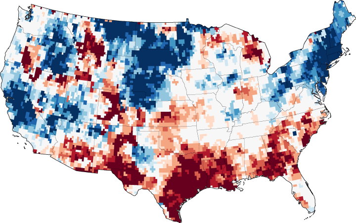
The map above depicts the amount of groundwater stored underground in the continental United States on November 28, 2011, as compared to the long-term average from 1948 to 2011. Deep reds reveal the most depletion, with deep blues representing aquifers and soils that are nearly full. The maroon shading over eastern Texas, for example, shows that the ground has been this dry less than two percent of the time between 1948 and the present.
At the end of November 2011, groundwater supplies were extremely depleted in more than half of Texas, as well as parts of New Mexico, Louisiana, Alabama, and Georgia. The northeastern states and the High Plains appear saturated with water heading into winter months.
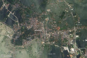
 As flood waters continue to inundate Thailand and drought parches Texas, the Intergovernmental Panel on Climate Change and Goddard Institute for Space Studies Director James Hansen have both released new statements about the connection between extreme weather and climate change. Although linking extreme weather weather to climate change has generated controversy in the past, both of the new reports point plainly to a connection. The IPCC, an international organizational that represents the scientific consensus of hundreds of leading climatologists, put it this way in the executive summary of its new report.

