Archives for category: Remote Sensing

[yframe url=’http://www.youtube.com/watch?v=cBHsdjPYLsk’]

By analyzing nearly a decade of satellite data, a team of scientists led by researchers from the University of California, Irvine and funded by NASA has created a model that can successfully predict the severity and geographic distribution of fires in the Amazon rain forest and the rest of South America months in advance.

Though previous research has shown that human settlement patterns are the primary factor that drives the distribution of fires in the Amazon, the new research demonstrates that environmental factors – specifically small variations in ocean temperatures – amplify human impacts and underpin much of the variability in the number of fires the region experiences from one year to the next.

“Higher than normal sea surface temperatures in the Atlantic and the Pacific proved to be red flags that a severe fire season was on its way in four to six months,” said Yang Chen, the University of California, Irvine, scientist who led the research. Chen and his colleagues found temperature changes of as little as .25°C (.45°F) in the North Atlantic and 1°C (1.8 °F) in the Central Pacific can be used to forecast the severity of the fire season across much of the Amazon.

 NASA, November 2011

[yframe url=’http://www.youtube.com/watch?v=C8mhGBzPK50′]NASA’s latest Earth-observing satellite, the NPOESS Preparatory Project (NPP), is scheduled to launch from Vandenberg Air Force Base on Oct. 28 to extend key environmental data records established by an earlier generation of NASA satellites. To mark the launch, we are looking back at one of the scientific legacies NPP will build upon: the global fire data record. An instrument on NPP called the Visible Infrared Imager Radiometer Suite (VIIRS) will extend this decades-long record into the future.

For more than a decade, instruments on Terra and Aqua, two of NASA’s flagship Earth-observing satellites, have scanned the surface of our planet for fires four times a day. The instruments, both Moderate Resolution Imaging Spectroradiometers (MODIS), have revolutionized what scientists know about fire’s role in land cover change, ecosystem processes, and the global carbon cycle by allowing researchers to map the characteristics and global distribution of fires in remarkable detail.

The two instruments have detected more than 40 million actively burning fires and observed nearly 10 billion acres of charred land during tens of thousands of orbits. They have extended and refined upon about 20 years of data from a predecessor instrument — the Advanced Very High Resolution Radiometer (AVHRR) — that orbited aboard a series of polar-orbiting weather satellites managed by…

NASA, October 2011

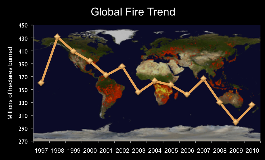
Wildfires that have destroyed more than a thousand homes and threaten thousands more continue to rage in central Texas. Meteorologists point out that drought and an influx of wind from Tropical Storm Lee have fanned the flames and fueled the rash of fires, the most severe Texas has experienced in recent memory. But what do we know about the broader context of the fires? Can we say with any certainty, for example, that fires have become more common in the United States – and across the globe – in the last few decades as global temperatures have increased? The answer to that question, I found after hunting through various journal articles and checking in with some of Goddard Space Flight Center’s fire specialists, is complex. Satellites offer the most comprehensive and reliable measure of the amount of land burned each year; however, satellite-based records of fire activity are still…

What on Earth, September 2011