Archives for category: 2013

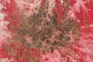
On the afternoon of January 14, 2013, a fierce bushfire swept across the campus of Siding Spring Observatory, a world-class astronomy facility on a ridge in Australia’s Warrumbungle National Park. The observatory is home to some of the most powerful sky-mapping telescopes in the world.

Ten years earlier, a brush fire devastated one of Australia’s other top observatories, so the staff of Siding Spring feared that history was repeating itself. As the fire reached the observatory’s campus, cameras and telescopes sent back disturbing images of flames lapping at the doorsteps of buildings and smoke billowing overhead.

By nightfall on January 14, the situation looked dire to the scientists and staff who had evacuated and were left to monitor the situation online. A handful of buildings on the campus were on fire. At one point, a thermometer on campus recorded a spike in air temperatures to 100 degrees Celsius (212 degrees Fahrenheit).

Read full story at:

Earth Observatory, February 2013

For centuries, traders along the Silk Road relied on the oasis at Dunhuang for a reprieve from the withering sunlight and heat of the Gobi desert. By 2011, a large solar farm on the outskirts of the city had started transforming that searing light into an energy resource for the region.

The Advanced Land Imager (ALI) on the Earth-Observing-1 (EO-1) satellite captured this series of images showing the installation of solar power panels on the outskirts of Dunhuang in the Gansu province of western China. In 2006 (top image), barren desert dominated, except for the road and a few patches of agricultural fields (lower right). By 2011 (middle image), grids of photovoltaic panels began to appear in large numbers. By 2012 (lower image), thousands of square meters were covered.

China’s State Development & Investment Corporation and the China Guangdong Nuclear Power Corporation (CGNPC) began construction in the area in August 2009, according to China Daily. Two 10-megawatt (.01 gigawatt) facilities were opened by July 2010, making the site China’s first large-scale solar power station.
Read full story at:

Earth Observatory, February 2013
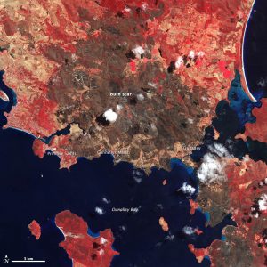
In January 2013, intense bushfires blazed in Tasmania, an island state of Australia. One of the hardest hit towns was Dunalley, a fishing village on the eastern coast. A blaze destroyed at least 80 homes—about 30 percent of the town— when it tore through the area on January 4, 2013. In the nearby village of Connellys Marsh, 40 percent of the buildings were destroyed. Primrose Sands lost several homes as well.

The Advanced Spaceborne Thermal Emission and Reflection Radiometer (ASTER) on NASA’s Terra satellite captured this image of the charred landscape on January 14. Vegetation-covered land is red in the false-color image, which includes both visible and infrared light. Patches of unburned forest are bright red, in contrast with areas where flecks of light brown indicate some burning. The darkest brown areas are the most severely burned. Buildings, roads, and other developed areas appear light gray. Clouds are white.

Read full story at:

Earth Observatory, February 2013

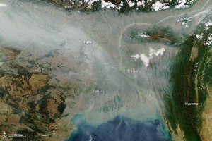
As is often the case in the winter, a thick river of haze hovered over the Indo-Gangetic Plain in January 2013, casting a gray pall over northern India and Bangladesh. On January 10, the Moderate Resolution Imaging Spectroradiometer (MODIS) on NASA’s Aqua satellite captured this image of haze hugging the Himalayas and spilling out into the Ganges delta and Bengal Sea.

The haze likely resulted from a combination of urban and industrial pollution, agricultural fires, and a regional meteorological phenomenon known as a temperature inversion. Usually the air higher in the atmosphere is cooler than the air near the surface, a situation that allows warm air to rise and disperse pollutants. However, cold air often settles over northern India in the winter, trapping warmer air—and pollution—close to the surface, where it has the greatest impact on human health.

Read full story at:

Earth Observatory, February 2013