Archives for category: 2012

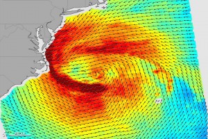
The scenes of devastation and wreckage that Hurricanes Sandy (2012) and Katrina (2005) left behind were tragically similar. Both storms flooded major cities, cut electric power to millions, and tore apart densely populated coastlines. But from a meteorological perspective, the storms were very different.

Katrina was a textbook tropical cyclone, with a compact, symmetrical wind field that whipped around a circular low-pressure center. Like most tropical cyclones, Katrina was a warm-core storm that drew its energy from the warm waters of the tropical Atlantic Ocean. Sandy had similar characteristics while it was blowing through the tropics. But as the storm moved northward, it merged with a weather system arriving from the west and started transitioning into an extratropical cyclone.

Read full story at:

Earth Observatory, February 2013

teds woodworking review

Mine Collapse in Turkey

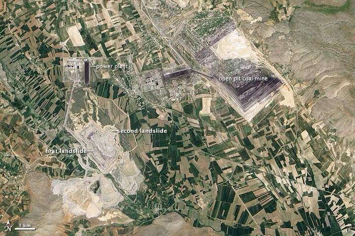
At 10 a.m. on February 10, 2011, disaster struck the Çöllolar coalfield in central Turkey, near the city of Elbistan. The northeastern wall of an open-pit mine collapsed, sending about 50 million tons of material into the mine. The debris buried and killed ten workers.

The collapse was the second at the same mine within a week. Four days earlier, a smaller landslide damaged the opposite wall and killed one person. According to a United Nations report, debris from the two landslides covered 2.73 square kilometers (1 square mile). The larger landslide extended 350 meters (1,150 feet) past the original perimeter of the pit. Inadequate drainage of the mine walls likely caused the landslides, according to Caner Zanbak, an environmental adviser to the Turkish Chemical Manufacturers Association.

Read full story at:

Earth Observatory, June 2012


Siberia Burns

Siberia Burns

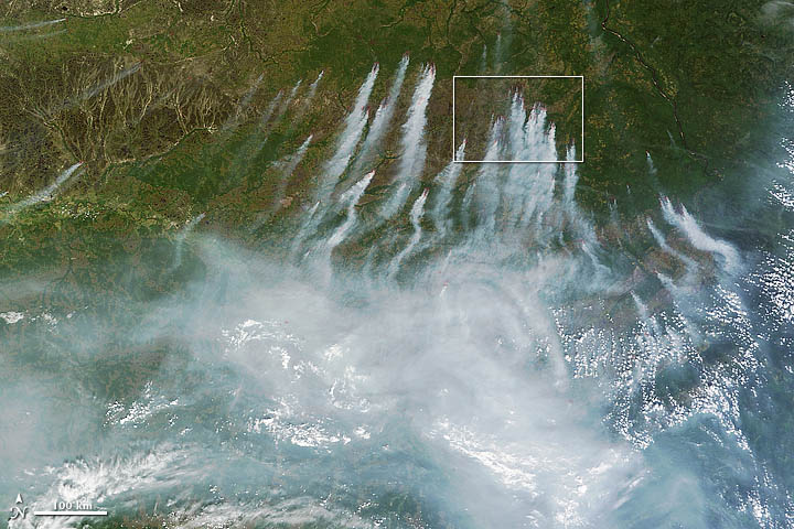
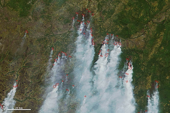
On June 18, 2012, a total of 198 wildfires burned across Russia and had charred an area that covered 8,330 hectares (32 square miles). Many were in central Russia, where firefighters have battled uncontrolled fires for months.

The latest flare-up prompted Russian authorities to declare a state of emergency in seven regions, including the Khanty-Mansiisk autonomous area, the Tyva Republic, the Sakha Republic, Krasnoyarsk, Amur, Zabaikalsky, and Sakhalin.

Read full story at:

Earth Observatory, June 2012

A Monster Slide

A Monster Slide

A Monster Slide

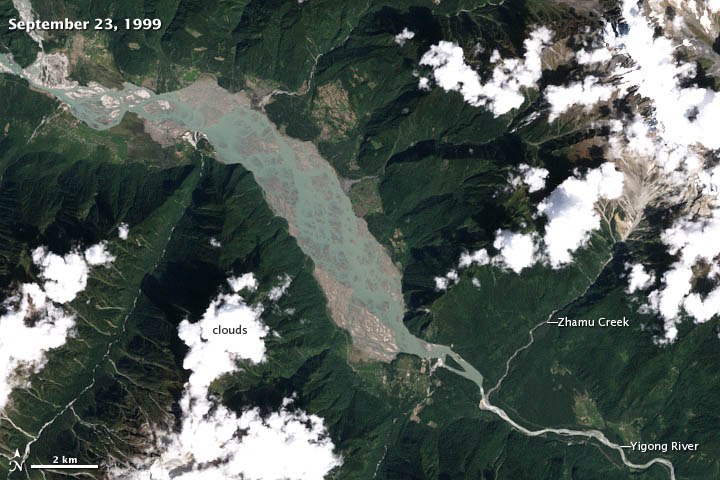
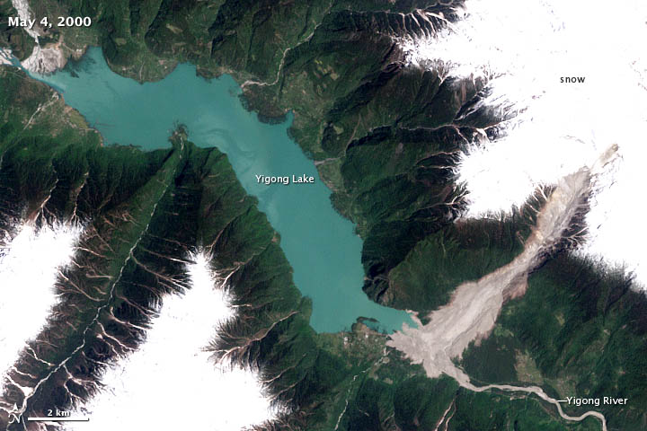
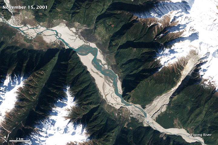
One of the world’s largest recorded landslides occurred on April 9, 2000, when more than 100 million cubic meters (3.5 billion cubic feet) of loose rock, ice, and other debris tumbled down a steep, narrow gorge in eastern Tibet.

Within ten minutes, the slurry of debris—which included granite and marble boulders, snow, and sediment—moved nearly 10 kilometers (6 miles) and dropped from an elevation of 5,520 meters (18,110 feet) to the valley floor 2,190 meters above sea level. The debris, lubricated by recent rainfall and meltwater from glaciers on the surrounding mountain peaks, slid through a gully carved by Zhamu Creek at velocities up to 14 meters per second (31 miles per hour).

By the time the mass of material stopped, it had buried the Yigong River, creating a debris dam that blocked the flow of the river. The dam occupied 2.5 square kilometers (1 square mile) and was 90 meters (295 feet) high at its tallest edge. River water began to back up immediately, creating a large lake behind the dam. As time passed, increasing volumes of water began to seep through the bottom of the dam, muddying the river water downstream. Meanwhile, the area and volume of the lake continued to grow.

Read the full story:

Earth Observatory, June 2012

Wheat Fires in China

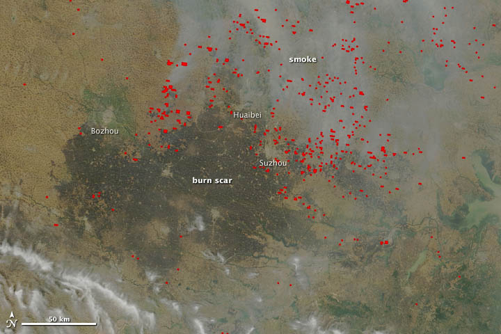
In mid-June, agricultural fires and industrial pollution combined to leave a thick pall of haze over central China. The Moderate Resolution Imaging Spectroradiometer (MODIS) on NASA’s Terra satellite captured these true-color (top) and false-color (bottom) images of the fires and haze. Both images were acquired at 10:55 a.m. local time (02:55 UTC) on June 13, 2012.

Smoke and actively burning fires (shown with red outlines) are visible in the true-color image, as well as a large burn scar. The false-color image reveals details of the burn scar that aren’t readily apparent in the true-color view. Although the burn scar looks uniform, the false-color view indicates that numerous fields with unburned vegetation (shown as green) are scattered throughout the area. The cities of Bozhou, Huaibei, and Suzhou, which appear as gray patches, were the closest cities to actively-burning fires when Terra acquired the images.

Read full story:

Earth Observatory, June 2012

An Australian “Anti-storm”

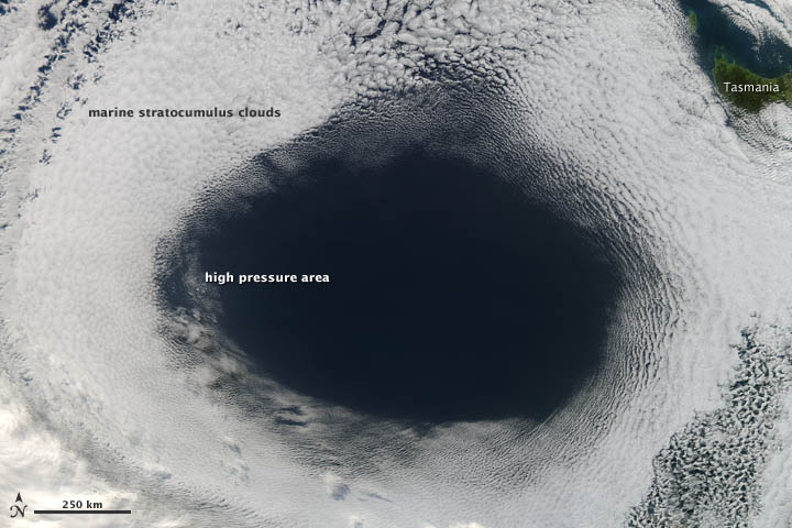
High-pressure weather systems often bring fair weather and relatively clear skies. In early June 2012, a high off the coast of Tasmania did just that…and in spectacular fashion.

The Moderate Resolution Imaging Spectroradiometer (MODIS) on NASA’s Aqua satellite acquired this view of a hole in a cloud formation at 3:00 p.m. local time (05:00 Universal Time) on June 5, 2012. The weather system over the Great Australian Bight cut out the oval-shaped hole from a blanket of marine stratocumulus clouds.

The cloud hole, with a diameter that stretched as far as 1,000 kilometers (620 miles) across, was caused by sinking air associated with an area of high pressure near the surface. Globally, the average sea-level pressure is about 1013 millibars; at the center of this high, pressures topped 1,040 millibars.


Read full story at:

Earth Observatory, June 2012