
In January 1841, James Clark Ross was leading an expedition to find the South Magnetic Pole when he encountered a nearly perpendicular cliff that extended as far as the eye could see. Though there were mountains beckoning to him in the distance, “We might with equal chance of success try to sail through the cliffs of Dover, as to penetrate such a mass,” the British naval officer wrote in his account of the expedition.
What Ross had encountered was the edge of an ice shelf—one of the many enormous slabs of floating ice along Antarctic coastlines. These shelves form as glaciers flow off the land into cold seawater, float, and fan out on the water surface in thick slabs. There are twelve major ice shelves in Antarctica. Although some have thinned in recent decades, many would look roughly similar today to what Ross and his crew would have seen when they explored much of Antarctica’s coastlines between 1841 and 1843.
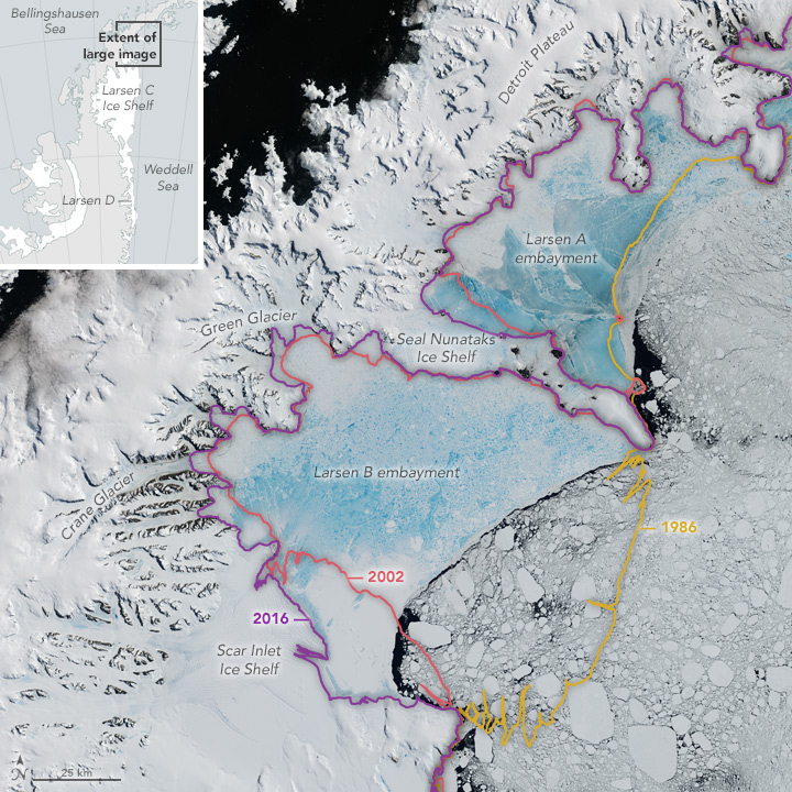
Of those twelve, the Larsen Ice Shelf, which was named after Carl Anton Larsen, would stand out to early explorers of Antarctica for showing dramatic change. Larsen is situated along the northeastern coast of the Antarctic Peninsula, one of the fastest-warming places on the planet. In the past three decades, two large sections of the ice shelf (Larsen A and B) have collapsed. A third section (Larsen C) seems like it may be on a similar trajectory, with a new iceberg poised to break away soon.
The mosaic above, centered on the northern part of Larsen Ice Shelf, is comprised of four natural-color satellite images captured by the Operational Land Imager (OLI) on Landsat 8 on January 6 and 8, 2016. It shows the remnant of Larsen B, along with the Larsen A and smaller embayments to the north covered by a much thinner layer of sea ice. The remaining shelf appears white with some deep rifts within it.
Read the full story at
NASA Earth Observatory, February 2017